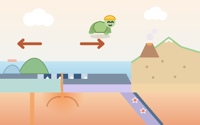
An earth-science reasoning game about plate tectonics. The screen is a cross-section of the crust: beige and dotted is continent, blue-grey is ocean crust, and the warm orange below is the mantle. Each plate is numbered and can take five speeds: west fast, west slow, still, east slow and east fast (4 or 2 cm a year, about as fast as fingernails grow). One press of "Go" is 10 million years, and a simplified grid model (one square = 100 km) acts out what happens next.
Where plates part, magma rises into new seafloor (a mid-ocean ridge), and a continent being pulled apart first opens a rift. Where plates meet, the heavier one sinks into a trench and volcanoes grow on the plate above: ocean crust is heavier than continents, and between two oceans the older one is heavier. Two continents can't sink, so they crumple into mountains. Earthquakes are marked at subduction zones, ridges and collisions, and under a trench they get deeper toward the plate on top. Each level has a "geology request" list, such as volcanoes on a certain plate, mountains 3 steps high, a sea exactly 8 squares wide or a coast stopping at a flag, and everything must be ticked when the last period ends.
There are 5 chapters and 30 levels: Apart and Together, Who Sinks?, Only Relative Motion (with plates whose speed is locked), Seafloor Barcodes (new floor records the magnetic direction of each period, and you must match a sample barcode) and Hotspots and Island Chains (plates slide over a fixed hotspot, leaving islands that age, sink and become atolls). An endless Random challenge first simulates a hidden set of speeds and turns the result into a request, so every puzzle can be solved.
How to play
- Tap "Start the lab" to carry on from the first level you haven't cleared, or pick a chapter from "Levels". The first time you open a chapter, a professor's note explains its earth science with a small picture, and "Notes" on the title screen lets you read them again.
- Read the request list at the top, then pick plates and set their speeds with ‹ ›. Small signs under the cross-section preview each boundary: arrows pointing in mean "meeting", arrows pointing out mean "parting", two bars mean "quiet". A plate with a padlock has a fixed speed. Press "Go" to watch 10 million years, and the professor explains what happened. In levels with several periods you can change the speeds before each one.
- Every item on the list must be ticked when the last period ends. In barcode levels, the "Now" row under the picture must match the "Sample" row; in hotspot levels, the islands must sit on the dashed outlines; in flag levels, the coast must stop exactly at the flag.
- Finishing without rewinds or hints earns 3 stars, 1–2 rewinds or a hint 2 stars, and more 1 star. The light bulb tells you the speed one plate needs for the next period. You can't fail and there is no timer: if a goal is missed you are told which one, and you can rewind one period or restart. Clearing 3 levels of a chapter opens the next one.
Controls
- Phone / tablet: tap a plate button below (or a plate in the cross-section) to pick it, then use ‹ › on either side to change its speed (west fast, west slow, still, east slow, east fast). You can also swipe left or right on a plate in the picture. Press "Go" to see what 10 million years do. The double arrow rewinds one period, the bottom-left button restarts, and the light bulb gives a hint.
- Mouse: the same as touch; click the buttons or drag sideways on a plate.
- Keyboard: ↑ ↓ (or Tab, or 1–4) pick a plate, ← → change its speed, Enter or Space fast-forwards; U rewind, R restart, H hint, M mute, Esc back.
For parents
- Made mainly for teens, and 9–12-year-olds can start with the first two chapters. It covers school earth science on plate tectonics: divergent and convergent boundaries (subduction and collision), ridges and rifts, trenches and volcanic arcs, why ocean crust subducts (density and age), the Wadati–Benioff zone (earthquakes getting deeper), magnetic stripes as evidence for seafloor spreading, and hotspots with island chains such as Hawaii. It also practises "speed × time = distance" and reasoning about relative motion. A good talk: why are Japan, the Andes, the Himalayas and Iceland where they are?
- The pictures show gentle landscape change only: volcanoes are small hills with white steam, with no eruptions, lava flows, disasters or people in danger, and earthquakes are just small star marks. There is no failure and no timer; a missed goal is named kindly, and you can rewind one period or restart. Continents and ocean crust also differ by dotted texture, plates are numbered, and magnetic direction has up and down triangles, so nothing depends on colour. The model is simplified (five speeds, a grid of 100-km squares) because the point is cause and effect, not exact numbers.
- No chat, in-app purchases, ads, outbound links or online leaderboards, and no personal details are ever asked for. Stars, seen notes, the number of random puzzles solved and the mute setting are stored only in this device's browser, and the game also works offline.